Every map of Vineyard begins with one drawn in 1778 by a man most people in Utah have never heard of. His name was Bernardo de Miera y Pacheco, and he rode with Fathers Domínguez and Escalante into Utah Valley in September 1776.
The mapmaker
Miera was born on August 4, 1713, in the Valle de Carriedo in Cantabria, in northern Spain. He came to New Spain as a young man and settled on its far northern frontier in New Mexico. He was a soldier and a militia captain, an engineer, a public official and one of the best religious artists in the colony. He carved and painted altar screens for churches in Santa Fe. One account says he stood only about five feet tall.
When the friars set out from Santa Fe on July 29, 1776, to look for an overland road to Monterey in California, they recruited the retired captain to draw the country they crossed. He was in his sixties, and the trip was hard on him. He fell sick more than once on the long ride home, and the party ate some of its own horses to survive.
Drawing the valley
In Utah Valley Miera did what he came to do. He took sightings, sketched the rivers and named what he saw. On his map the long range above the valley is the Sierra de los Timpanogos, the name the mountain still carries. The river the friars reached on the east shore, today's Provo River, is the Río de San Antonio de Padua. A few miles north he drew another stream, the Río de Santa Ana, which historians read as the American Fork. Villages of the Timpanogos people line the east shore of the lake, the shore where Vineyard sits.
His instruments were good but not perfect. On September 24, 1776, he measured the party's latitude in Utah Valley at 40 degrees 49 minutes. If that reading had been right, the camp would have been near present day Sandy in the Salt Lake Valley.
One lake, not two
His biggest error was understandable. The Timpanogos told the friars that their lake connected to a much larger, salty lake to the north. Miera never saw it, so he drew one body of water, the Laguna de los Timpanogos, with a narrow neck reaching north. It was really two lakes, Utah Lake and the Great Salt Lake, joined in his map by the Jordan River. Far to the southwest he drew a second lake from what the Utes described, and named it after himself: the Laguna de Miera, today's Sevier Lake.
Miera finished his map in Santa Fe after the party returned at the start of 1777, and copies of it made in 1778 still survive. It was the first map of the Great Basin and of Utah Valley ever drawn, and for decades it was nearly the only one.
The presidio could be placed in this Valle de Timpanogos.Bernardo de Miera y Pacheco, letter to King Charles III, October 26, 1777
A letter to the king
He also had plans for the place. On October 26, 1777, Miera wrote to King Charles III of Spain from Chihuahua. He told the king that several peoples wanted baptism, especially the Timpanogos. He proposed a presidio, a fort with soldiers, in the Valle de Timpanogos, which he described as more than thirty leagues long and twelve wide, to protect missions there, along with a Spanish town. He hoped it would anchor a chain of settlements reaching from New Mexico to the California coast.
Spain never acted on it. No presidio was built, no mission was founded, and the friars never came back. Utah Valley stayed Timpanogos country for another seventy years.
The river that was not there
Miera's map had a longer life than his plans. He had named the Green River the Río de San Buenaventura, and because the friars crossed it and later met the Sevier River far to the west, his map joined the two into one great river flowing southwest toward the Laguna de Miera. Later mapmakers stretched it further. The German geographer Alexander von Humboldt copied the friars' lake onto his map of New Spain, and others drew the Buenaventura, or a river out of Lake Timpanogos, running all the way to the Pacific Ocean.
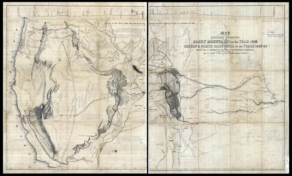
For more than half a century explorers went looking for that river. John C. Frémont finally laid it to rest. After his 1843 and 1844 expeditions he showed that the rivers of the Great Basin had no outlet to the sea at all. On his map the old Buenaventura is gone, and Utah Lake and the Great Salt Lake are two lakes.
Miera died in Santa Fe in April 1785. His Sierra de los Timpanogos still stands over Vineyard, and the lake he first put on paper is still at the end of the street.
From vineyardhistory.org/stories/mieras-map/